Routes & Discovery
Smart route discovery, real-time GPS tracking, community routes with elevation profiles, and a global Ascension Map across 50+ countries.
Why you'll love it
Discover nearby activities
Find parks, trails, beaches, gyms, climbing walls, and more across 18 activity types. Smart location search surfaces the best spots within any radius, from 500 m to 100 km.
Real-time GPS tracking
Track your run, cycle, hike, or walk with live GPS. See distance, pace, elevation gain/loss, per-kilometre splits, sprint detection, and step counting, all updating in real time on your map.
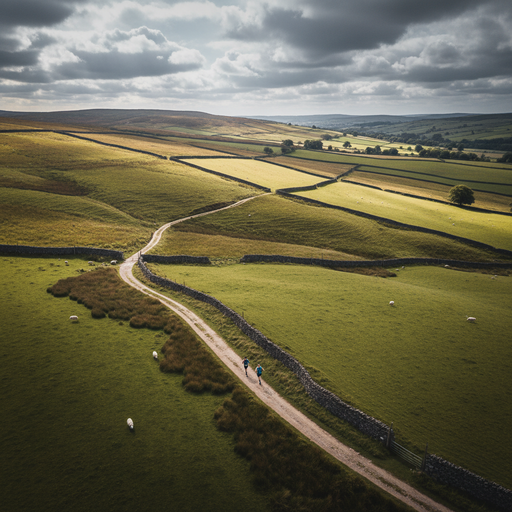
Community routes
Browse routes shared by other Ascend users with route maps and elevation profiles. Upvote, review, and bookmark your favourites. The best routes rise to the top.
Elevation profiles and terrain
Every route includes a full elevation chart. See total gain/loss, gradient sections, and terrain difficulty before you start so you know exactly what you are getting into.
Ascension Map
A global live map plotting Ascend users by their Ascension Score. Zoom across 50+ countries and see the community growing in real time with Bronze, Silver, and Gold tier markers.
Reviews, ratings, and voting
Rate routes, leave reviews, and cast upvotes or downvotes. Community feedback ensures quality. Every route carries an average rating, completion count, and popularity score.
GPX export
Export any route as a GPX file to use with your GPS watch or other navigation apps. Routes are optimised for smaller file sizes without losing route shape.
Smart filters and sorting
Filter by activity type, difficulty, route length, and radius. Sort by nearest, most popular, highest rated, or newest. Two-tab layout with both Map and List views.
Key capabilities
Community-powered routes
Every route is shaped by the community. Vote, rate, review, and contribute to help everyone find the best paths.
Upvote & downvote routes
The best routes rise to the top through community votes
Rate after completion
Leave a star rating and review once you finish a route
Suggest new routes
Publish your GPS track as a community route for others
Report issues
Flag blocked paths, safety concerns, or poor conditions
Community verified
Popular, well-rated routes earn a verified badge
Discover Nearby
Find running, cycling, hiking, and walking routes near you in seconds. Just open Discover Routes and Ascend instantly shows what's available within your chosen distance, from 500 metres to over 100 km away.
London & South East
34 citiesLondon, Brighton, Canterbury, Oxford, Reading, Southampton, Portsmouth, Guildford, Maidstone, Dover
Midlands & East
28 citiesBirmingham, Nottingham, Leicester, Norwich, Cambridge, Coventry, Derby, Northampton, Lincoln, Peterborough
North England
31 citiesManchester, Liverpool, Leeds, Sheffield, Newcastle, York, Bradford, Hull, Sunderland, Durham
South West
22 citiesBristol, Bath, Exeter, Plymouth, Bournemouth, Cheltenham, Gloucester, Salisbury, Truro, Taunton
Wales
18 citiesCardiff, Swansea, Newport, Bangor, Aberystwyth, Wrexham, Carmarthen, Brecon, Llandudno, Pembroke
Scotland
26 citiesEdinburgh, Glasgow, Aberdeen, Dundee, Inverness, Stirling, Perth, Fort William, St Andrews, Oban
Northern Ireland
16 citiesBelfast, Derry, Lisburn, Newry, Bangor, Armagh, Enniskillen, Coleraine, Omagh, Ballymena
Republic of Ireland
24 citiesDublin, Cork, Galway, Limerick, Waterford, Killarney, Sligo, Kilkenny, Wexford, Tralee
200+ cities covered across the UK and Ireland with smart location search
GPS Tracking
Real-time GPS tracking for running, cycling, hiking, and walking. Your route draws live on the map while distance, pace, elevation, splits, sprints, and steps update continuously. A fallback system ensures tracking continues even in poor-signal areas.
Live Route Drawing
Your route draws on the map in real time as you move. Every GPS point is captured and rendered as a smooth route line on your map.
Per-km Splits
Automatic split timing every kilometre. See exactly where you sped up, slowed down, or held a steady pace across your route.
Elevation Tracking
Real-time altitude monitoring with a 2-metre noise threshold. Total gain and loss update live, filtering out GPS elevation jitter.
Sprint Detection
Activity-specific speed thresholds detect sprints automatically. Running triggers at 10 km/h; cycling at higher thresholds.
Step Counter
Accelerometer-based step counting using peak-valley detection. No pedometer hardware required. Works on any phone with sensors.
Continuous Tracking
A background system ensures position updates even with poor satellite signal. No dead zones. Tracking continues everywhere.
Route Details
Every route in Ascend carries rich metadata: distance, elevation, difficulty, activity type, estimated duration, average pace, terrain tags, and geo-tagged city/country. The route detail screen includes a full-width map, interactive elevation chart, voting, reviews, and social sharing.
Distance
Metres and kilometres
Elevation Gain
Total ascent in metres
Difficulty
Easy, Moderate, Hard, Expert
Activity Type
Run, Walk, Cycle, Hike
Estimated Time
Duration in minutes
Avg Pace
Min/km or km/h
Terrain Tags
Trail, Road, Mixed, etc.
City / Country
Geo-tagged location
Community Routes: shared by Ascend users
After completing a GPS-tracked workout, users can publish their route to the community. Published routes include the full route line (optimised for smaller file sizes), elevation data, activity type, difficulty, and location metadata. Other users discover these routes via the Route Discovery screen, which offers a two-tab layout with a Map view with route overlays and a scrollable List view. Filter by activity, difficulty, and route length, then sort by nearest, most popular, highest rated, or newest.
Ascension Map
A real-world map visualisation where every Ascend user is plotted by their Ascension Score. The map renders Bronze, Silver, and Gold tier markers across 50+ countries. Zoom in to find climbers near you, or zoom out to see the global community at a glance.
50+
Countries
100K+
Active Users
3
Tiers
Live
Real-time
Bronze
0 - 200Starting your journey. Every workout, every step, every rep moves you closer to Silver.
Silver
200 - 500Consistent dedication. You have built real habits and your Ascension Score reflects it.
Gold
500 - 950+Elite tier. You are among the most dedicated users on the platform. Your marker glows on the map.
Supported activity types
Routes and GPS tracking support four core activity types, each with tailored metrics, sprint thresholds, and tracking behaviour.
Running
Road running, trail running, and track sessions. Sprint detection auto-triggers above 10 km/h with per-km splits and pace tracking.
Cycling
Road cycling, mountain biking, and commutes. Speed and distance tracked with elevation gain for climbing performance analysis.
Hiking
Day hikes, multi-day treks, and fell walking. Elevation profiles highlight steep ascents and descents with total gain/loss.
Walking
Daily walks, power walking, and urban exploring. Step counting via accelerometer with distance and pace at lower thresholds.
Swipeable Discovery Cards: 18 activity types
The Amenity Discovery screen uses swipeable swipe-to-explore cards to surface parks, trails, beaches, gyms, climbing walls, pools, viewpoints, campsites, and more. Each card shows real Google Places photos, distance from you, opening hours, and community ratings. Swipe right to bookmark, swipe left to skip.
Ready to start?
Download Ascend today and get a free 7-day Elite trial. No credit card required.